Dolores 2023/2024 Forecast Comparison
Key Findings
4 ASO Snow Surveys Flown In 2023 and 2024
4 surveys were flown over the Dolores River Basin between 2023 and 2024 resulting in 8 ASO WRF-Hydro forecasts, each of which were critical to the operation of McPhee Reservoir throughout the runoff and irrigation seasons.
Snowpack Measurement During Outlier Years
NRCS SNOTEL Basin Indices provided insufficient information to accurately predict the total runoff during 2023 and 2024, both extreme outlier years.
ASO WRF-Hydro seasonal inflow forecasts had a maximum error of around 15% while the operational RFC forecasts had a maximum error of around 70% of final observed seasonal streamflow.
ASO-informed forecasts improved operational decision making
ASO-observed snowpack resulted in much lower McPhee Reservoir inflow forecasts that validated much closer to observations than the RFC forecast. This improved operational decision making resulting in optimized McPhee reservoir releases.

Project Background
The Dolores River Basin is a snowmelt-dominated basin located in the southwest corner of Colorado’s iconic San Juan mountains. Runoff into the Dolores River system sustains a large amount of irrigated agriculture, gold medal trout fisheries, and a growing river boating recreational community. These industries provide critical revenue into local economies. Dolores River water also is an important contributor to downstream flows into the Uncompahgre and then Colorado Rivers thereby playing an important role in the overall reliability of Colorado River flows. As one of the most southerly basins in Colorado, the Dolores River basin is increasingly influenced by warming trends associated with global climate change and has already seen decreases in the seasonal duration of snow cover as well as prolonged periods of low flow conditions.
From a water management perspective, the primary control on the Dolores River resides at McPhee Reservoir which stores and releases water to the lower Dolores River basin. The Dolores Water Conservancy District (DWCD) manages McPhee Reservoir and has been a regular user of ASO data since 2021. The DWCD must carefully balance the competing uses on the Dolores River (irrigation, fish health, recreational releases) with the goal to ultimately refill the reservoir prior to each year’s irrigation season. Operation of the reservoir is highly influenced by snowpack observations and runoff forecasting from the upper Dolores River basin. As a southerly basin, it is typically one of the first basins in the Upper Colorado River Basin to initiate seasonal runoff as early as early-to-mid-March in some years implying that typical April 1 metrics of snowpack are potentially, and will increasingly be, inadequate to predict total seasonal runoff. Runoff from the summer monsoon season typically adds a significant, but small fraction of additional flow into the Dolores River system. Therefore, there is a premium on the availability and accuracy of snowpack information towards the end of winter and the ability of models to accurately predict the timing and amount of seasonal flows.
ASO Application
The Dolores Basin has received ASO snow surveys in 2021, 2023, 2024, and 2025. Survey timing for the Dolores was designed to capture the same key benchmarks used in other basins:
Late winter conditions prior to peak SWE
Melt season conditions immediately following peak SWE
Snowpack conditions once all basin SNOTEL sites have melted out
For the Dolores, these ASO flights provided a complete picture of snow distribution across the headwaters above McPhee Reservoir and the upstream tributaries. Having distributed snowpack information at these key moments allowed managers to understand not only the total snow water volume available, but also its location in subbasins. This spatial detail gave water managers greater confidence in forecasts and storage operations, particularly in years when traditional indices suggested near‐median conditions but actual runoff proved to be critically low or unexpectedly high.
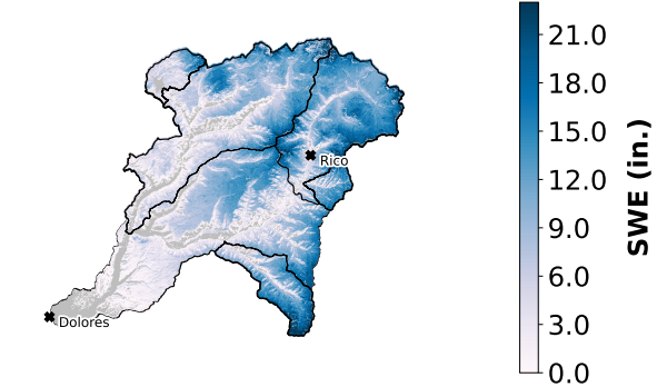
Snowpack
The Dolores River basin shows how snowpack and runoff don’t always line up the way you’d expect. The chart on the right shows SWE from NRCS monitoring stations for the Dolores Basin (Source). In 2024, snowpack grew into the highest on record. By contrast, 2023 hit near a “normal” SWE but still produced very low inflows. These two years highlight that poitn measurements of snowpack don’t tell the whole story about water supply.
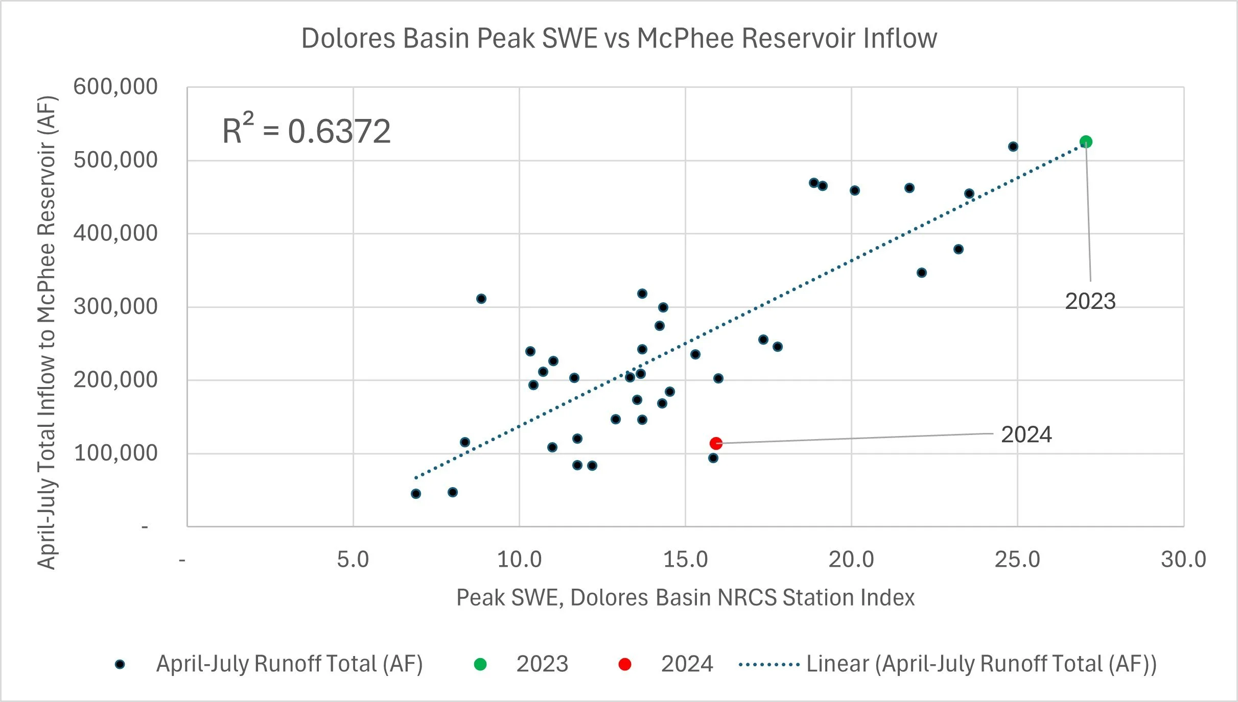
The chart on the bottom right compares peak snow water equivalent from NRCS SNOTEL stations (SWE) with April–July inflows to McPhee Reservoir (USBR Source). Overall, more snow means more inflow, but the scatter and relatively poor R^2 of 0.63 shows the uncertainty in using only a point measurement to make that case. The years 2023 (green) and 2024 (red) stand out as clear outliers, with inflows much higher or lower than the line would suggest. That gap shows how a more accurate snowpack measurement like is delivered from CASM, along with springtime conditions things like soil moisture, spring temperatures, and timing of melt matter just as much as the total snowpack.
A record snowpack year like 2024 may still bring disappointing runoff, while a near-average year like 2023 can turn out critically dry. Going forward, ASO flights are critical to provide McPhee Reservoir operators with more accurate snowpack information and forecasts ahead of the runoff season.

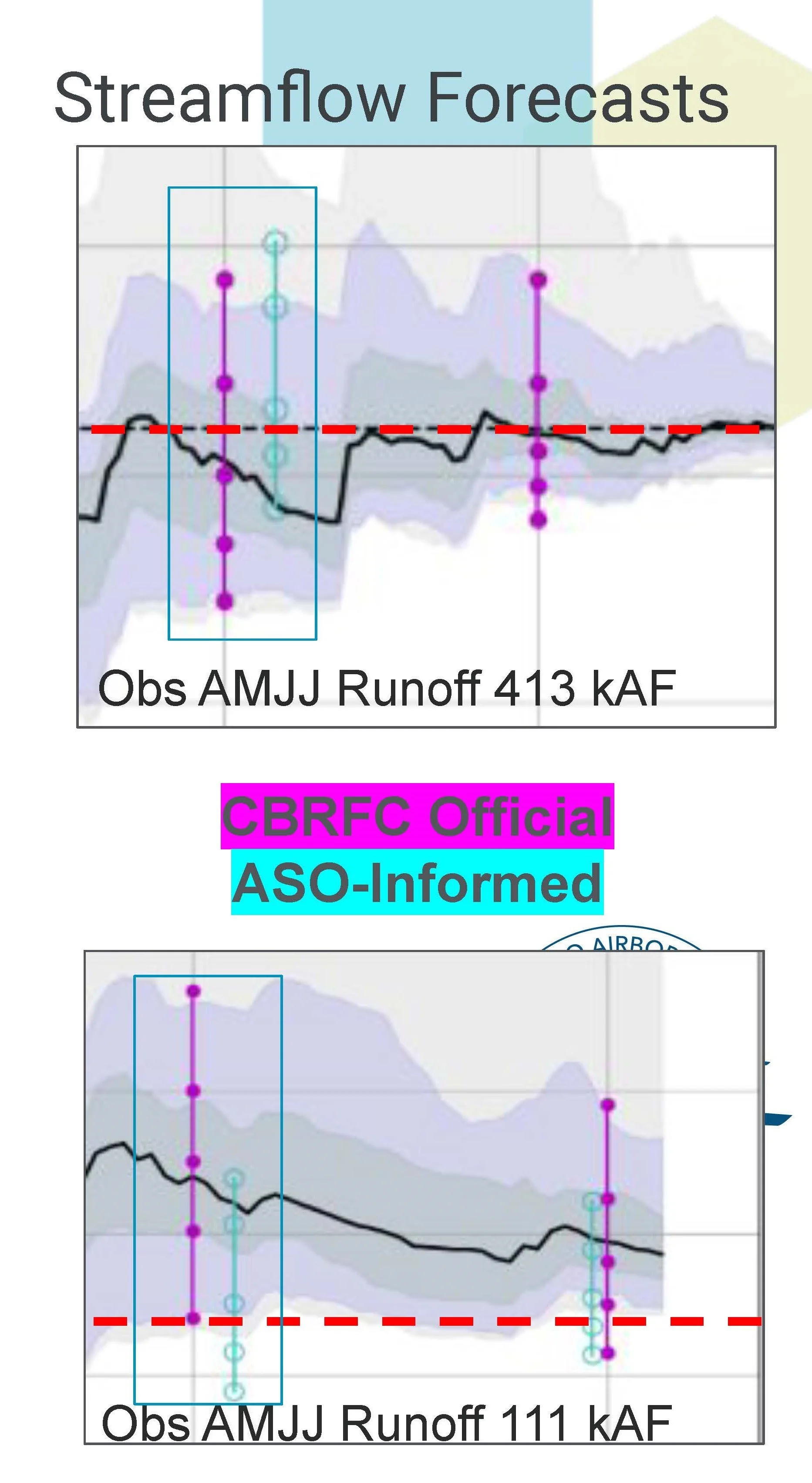
Streamflow Forecasts
These plots show the official CBRFC Forecasts (Purple), Experimental ASO-Informed Forecasts (Cyan) and the observed runoff (Red Dashed) for water years 2023 and 2024. The boxes show the comparative precision of the ASO-informed compared to the CBRFC official forecasts.
In 2023, the Dolores River made national headlines with its high runoff and rare, extended boating season. An ASO snow survey was conducted on April 6th, 2024, ahead of the runoff season. The ASO-informed experimental and WRF-Hydro streamflow forecasts showed a range in the upper half of the CBRFC forecast ensemble. The final total runoff was nearly the median of the 2023 ASO-Informed forecasts.
Conversely, 2024 was a particularly dry year for southwest Colorado. An ASO snow survey was conducted on April 4th, 2024 which confirmed that there was very little snow in lower elevation areas that have traditionally provided a large portion of the runoff to McPhee reservoir. The April 1st official seasonal runoff forecast (AMJJ) for the Dolores River showed a very different picture than ASO informed results. The ASO-derived forecast was entirely in the lower half of the official forecast ensemble. The final observed runoff was in the middle of the CBRFC Experimental Forecast Ensemble.
In both cases, the ASO-informed forecast was more precise than the official forecast in the early season. This allowed the DWCD to make key management decisions early in the year around excess/insufficient inflow to McPhee reservoir. The integration of ASO-informed forecasts into their decision making processes allows the DWCD to use their water more efficiently and better optimize their annual operating plans.