


FAQs
Is there something we are missing that you want to know? Contact us here and we will get back to you, and add to this page.
-
CASM is the Colorado Airborne Snowpack Measurement workgroup. The CASM workgroup is working toward implementing a statewide program to conduct regular ASO flights and provide significantly improved streamflow forecasting throughout Colorado.
-
The Airborne Snow Observatories, Inc. (ASO Inc.) uses paired airborne lidar and imaging spectrometer sensors coupled with a snow dynamics model to measure snow depth and albedo and retrieve Snow Water Equivalent (SWE, the liquid depth of water stored in the snowpack) across large river basins at a high spatial resolution. The resulting data provides high-elevation snowpack measurements with detail, accuracy, and decision-support value unprecedented in water management.
The added value of these measurements to the water community has been thoroughly demonstrated through a multitude of pilot flights in Colorado and California. For example, in a 2019 pilot flight series in the Blue River watershed with Denver Water—during a time when the SNOTEL stations in the watershed had melted out—ASO data provided an accurate volume estimate of 115,000AF of water remaining in the high elevations. This provided Denver Water’s operations manager the information needed to accurately reduce Dillon Reservoir levels to account for the incoming runoff, which in turn allowed downstream reservoir operators and other Colorado River reservoir operators to retime outflows and cancel Coordinated Reservoir Operations (CROS) that could have otherwise led to downstream flooding and lost water supply.
ASO Inc. is a private company that was formed out of a project at the NASA Jet Propulsion Lab (JPL). ASO Inc. provides aircraft-based measurements of snow albedo and depth along a flight path. These physical measurements are combined with physically based snow density modeling to create a high resolution (3m) gridded measurement of snow water equivalent across a river basin. The fully processed snow water equivalent (SWE) measurements are colloquially referred to as “ASO Data”.
-
Traditional snowpack estimates using ground and satellite-based measurements can be off by as much as 40%, and sometimes more. ASO snowpack measurements have been shown to have bulk snowpack measurement uncertainty of 5-13% (Oeida 2019). Other recent studies have demonstrated the suitability and accuracy of airborne and terrestrial lidar data for differential mapping of snow depth in mountainous terra in (Hopkinson et al., 2004; Deems et al., 2006; Trujillo et al., 2007; Prokop, 2008; Mott et al., 2011; Deems et al., 2013a; Deems et al., 2015).
-
ASO, Inc. processes its flight data to generate a 3m resolution gridded snow depth product. This depth measurement, paired with the iSnobal energy balance model and ground-based density measurements, is used to generate a total snowpack water volume estimate at 50m resolution. Since most of the annual runoff from Colorado headwater basins comes from snowmelt, this ASO-derived snowpack volume can be assimilated into most existing runoff forecasting tools that rely on SWE estimates.
There are several ongoing academic and government research projects exploring different techniques for ASO assimilation to provide the most forecast improvement and maximize the value of this program. In 2022, the Weather Research and Forecasting Model Hydrological modeling system (WRF-Hydro, Gochis 2020) run by the National Center for Atmospheric Research (NCAR) was used to develop experimental streamflow forecasts for any basin with ASO flights. The Colorado Basin River Forecast Center (CBRFC) also provided a similar ASO-integrated experimental forecast.
-
CASM directly supports the goals of the Colorado Water Plan. All aspects of water availability and security are driven by the ability to properly measure and forecast Colorado’s water supply. All Basin Implementation Plans (BIPs) identify the need to manage risk around water supply availability, both for in-basin municipal and industrial (M&I), recreational, and environmental demands, Colorado River Compact administration, and other goals. The CASM program aims to directly address all of these high-level water management goals, ultimately allowing Colorado water stakeholders to do more with less. The widespread adoption of cutting edge ASO technology is in tradition with Colorado being a model of leadership in water sciences and water resource management throughout the US. A successful CASM program will have:
-Seasonal runoff forecasts in key headwater basins that show improved accuracy and uncertainty due to the integration of the ASO Inc. SWE measurements
-Continued integration of ASO data with the scientific research community to better understand changing snowpack characteristics and further develop runoff forecasts and water management decision support tools that are useful in a changing climate
-Improved understanding of the impacts on snowpack and water supply due to forest management, wildfire, and other major landscape changes.
-An engaged group of water management stakeholders that includes broad geographic diversity and water sector diversity throughout Colorado.
-Continued education and stakeholder feedback sessions around how to improve decision-making using this data
-Data that is openly accessible to any interested stakeholder
-State-led oversight of the program to ensure fairness and equity in survey coverage as well as program sustainability
-Sustainable funding that allows for multiple ASO surveys each year for the majority of high-elevation watersheds in Colorado. This should also include budget flexibility around where and when to conduct ASO surveys.
-
The current CASM vision for a fully developed ASO program would be funded to conduct 6-8 snow-on surveys per year across all snow-covered areas of Colorado. Peak SWE in Colorado typically occurs between April 1st and 15th, depending on the year type. During peak SWE, it would require around 25 surveys for a single snapshot statewide of snowpack across all key headwaters. As the snowpack recedes throughout the snow season, fewer flights are required to reach full coverage. At an upper limit, 215 flights per year would provide detailed measurements across all major headwaters of Colorado’s river basins from winter through the spring melt season. It is an active area of scientific research by the US Bureau of Reclamation, the California Department of Water Resources, the CWCB, and multiple academic research groups to balance data from ground-based networks with the high accuracy of ASO snow surveys throughout the accumulation and melt seasons, though 6-8 surveys per basin is the current best estimate. There have not been enough ASO flights yet in Colorado to truly answer this question of the optimum number of flights. The geography and snowpack dynamics of Colorado’s headwater basins is highly variable and needs to be studied in more detail.
As CASM grows, ASO flights should be conducted multiple times in headwater basins from winter through spring runoff season, while delivering improved runoff forecasts. As this program grows, the total number of flights per year will grow as well, based on stakeholder engagement, funding, and advancement of snow science.
-
Airborne lidar snowpack measurements have been conducted across Colorado since 2013, with numerous scientific, applied science, and operations support efforts. The following list details ASO activity in Colorado to date, along with funding source and application:
-Uncompahgre River above Ridgway Reservoir; 1-4 surveys per year 2013-2017: NASA Terrestrial Hydrology Program, Science support
-Grand Mesa; NASA Terrestrial Hydrology Program, Science support
-Rio Grande and Conejos Rivers; 1-2 flights per year 2015-2016, 2 surveys planned in Conejos 2021: CWCB Rio Grande Forecast Improvement Project; Applied science support, 2 surveys, 2022 CWCB Water Plan Grant Funds
-Upper Gunnison River (East and Taylor Rivers); 1-2 surveys per year 2016, 2018-2019, 2022: Dept. of Energy East River Watershed Function Scientific Focus Area, Science support, CWCB Project funds and 2022 CWCB Water Plan Grant Funds
-Blue River above Dillon Reservoir; 2 surveys 2019, 2021, 2022: Denver Water, Operations support
-Animas River above Durango; 2 surveys 2021: CWCB Project funds, Operations support
-Dolores River above McPhee Reservoir; 2 surveys 2022 CWCB Water Plan Grant funds, Operations support
-Willow Creek Reservoir, Granby Reservoir, Fraser River; 2 surveys, 2022 CWCB Water Plan Grant Funds
-
While it is required to have cloud-free conditions to conduct an ASO survey, careful coordination allows for snow surveys within a few days they are requested by stakeholders. However, there is some good news in that ASO flights can be conducted when wildfire smoke is present.
-
Ground-based snow-measurement stations are highly accurate but only at their specific point location and require statistical extrapolation models to make basin-scale snowpack estimates. Satellite-based products provide broad coverage, but are often at a coarse horizontal resolution (1km+ cells) and poor vertical resolution. Drone-based technologies are similar in resolution to ASO but cannot provide sufficient geographic coverage.
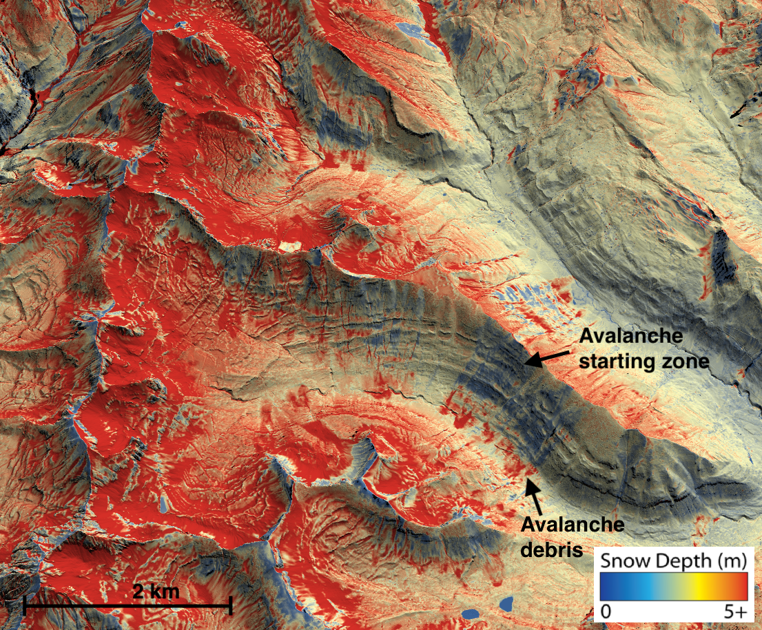
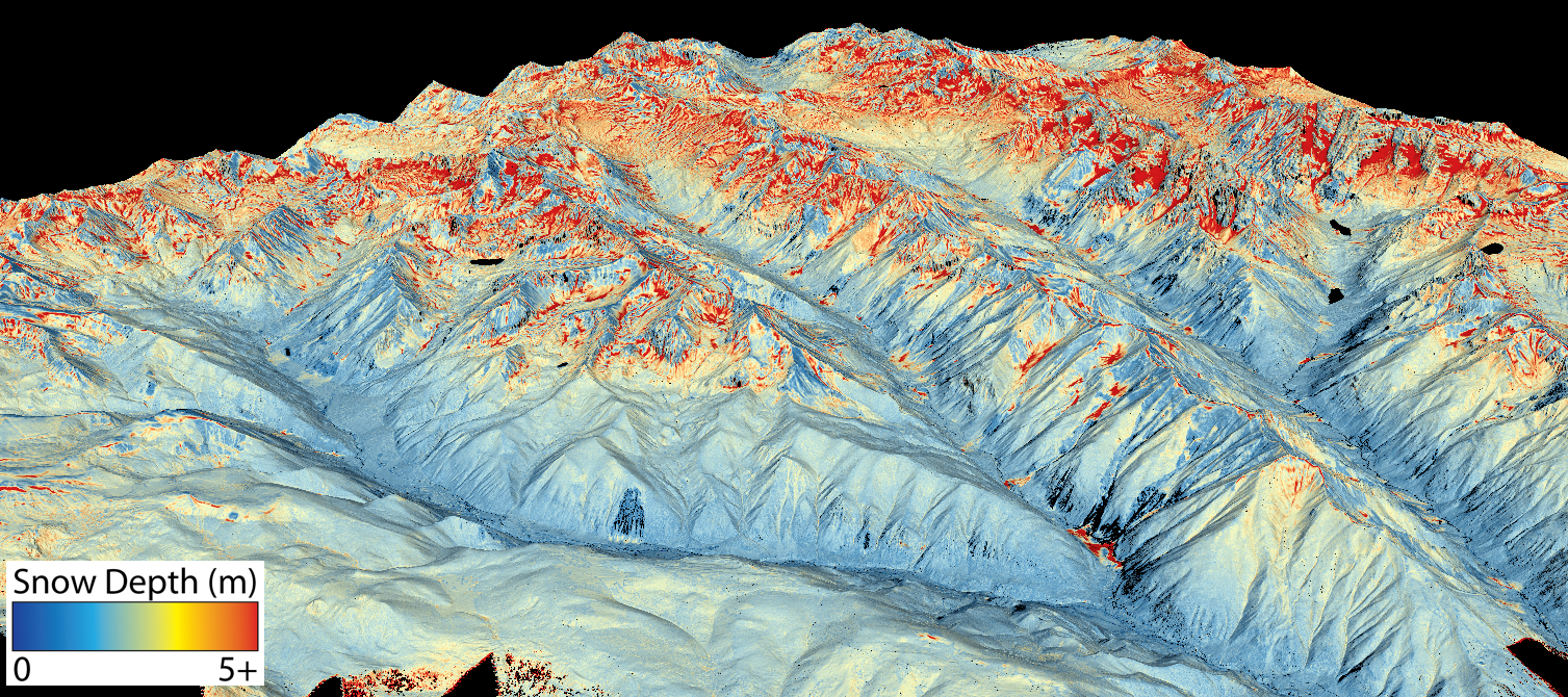
ASO is the only product that provides high accuracy, high resolution, complete measurements of snow depth and snow water equivalent at the basin scale. ASO snow depth data is natively 3m horizontal resolution and 1cm vertical resolution (8cm uncertainty).
-
Yes. As the snowpack changes with climate change, the historical snowpack record is becoming less and less reliable as an indicator for current snowpack conditions. Being able to accurately measure the snowpack at the watershed scale multiple times each year with ASO technology is a proven strategy for adapting to changing snowpack conditions.
-
An ASO snow survey provides a highly accurate estimate of the total volume of water contained in a basin’s snowpack at a single point in time. This measurement can be used to validate estimates of reservoir inflow, make predictions about total and peak runoff timing downstream, and provide a check on other snowpack estimates. If any of your planning efforts require a numeric estimate of total seasonal runoff, ASO can provide basin-scale estimates of SWE that provide a point in time estimate of the total water available in a basin.
For each ASO survey conducted in Colorado, the team at ASO, Inc. produces a post-survey report that summarizes the flight data. This report, and the associated raw data products, are freely accessible to the public and can downloaded from ASO, Inc’s website.
If you have ideas for a use case of this data for your sector, please reach out to the CASM planning team.
-
Results from ASO snow surveys are publicly available on the ASO Inc. website (https://data.airbornesnowobservatories.com/). These data are limited to locations where snow surveys have been flown, but include:
-Basin-wide estimate of SWE volume
-3m resolution snow depth gridded data
-50m resolution snow water equivalent gridded data
-Detailed survey reports outlining model and data assumptions
-
Rather than building new mountain storage, this project aims to optimize the use and knowledge of existing supplies. This project promotes collaboration across municipal water providers and will provide a mutually beneficial data product. This project aligns with these actions identified in section H of the Colorado Water Plan (Summary of Actions):
6.1.3 Scenario Planning & Developing an Adaptive Water Strategy - Promote use of scenario planning and adaptive strategies
6.1.5 Scenario Planning & Developing an Adaptive Water Strategy - Support innovative and collaborative science.
6.2 Meeting Colorado’s Water Gaps through the development of municipal partnerships
6.5.7 Municipal, Industrial, and Agricultural Infrastructure Projects and Methods – Storage Opportunity Assessment.
7.1.10 Watershed Health and Management - Coordinate statewide watershed-coalition and partnership plans, projects, monitoring, and adaptive management strategies
-
In 2010, Dr. Thomas Painter was recruited to the NASA Jet Propulsion Laboratory to lead the development of the program that would become the NASA Airborne Snow Observatory. He and his ASO team, along with partnership with the California Department of Water Resources, began in 2013 with breakthrough measurements and modeling of mountain snowpack that led to the first high-accuracy maps of distributed snow water equivalent across entire mountain basins. In 2019, Dr. Painter, Dr. Joe Boardman, Dr. Jeff Deems, and Pat Hayes founded Airborne Snow Observatories, Inc. to transfer the NASA technology to commercial operations available around the globe.
The Colorado Airborne Snow Monitoring (CASM) program was established and funded under a Water Supply Reserve Fund (WSRF) Grant in 2021. CASM’s mission is to improve water management across Colorado through widespread deployment of ASO flights.
-
In California, the Department of Water Resources manages the Airborne Remote Sensing of Snow (ARSS) program and deploys 30+ ASO flights per year across nine different basins in the Sierra Nevada mountains. Data from ARSS flights are used to improve runoff estimates, issued as part of the Bulletin 120 seasonal runoff forecast (https://cdec.water.ca.gov/snow/bulletin120/ CA DWR 2022). In the wake of the recent large wildfires in California, ASO data is also used to quantify the impact of fire damage on snowpack and runoff efficiency.
ARSS began in 2013 and has slowly scaled up over several years to provide 3-5 snow surveys per year across nine major basins in the Sierra Nevada. The CASM team has engaged closely with CA-DWR staff to understand some lessons learned and potential challenges of developing a program like ARSS. In 2022, ARSS is funding 31 flights and all the associated support activities at a cost of $9.5 Million.
-
As of 2022, ASO, Inc., the developer of this technology and application, is the only organization providing the combination of airborne lidar and spectrometer snow depth, SWE, and snow albedo data products along with rapid processing that meets the needs of the CASM program and other managers of snowmelt systems. Unless another company offers this service and can demonstrate a similar accuracy, timeliness, and product suite, ASO Inc. will be the sole provider of snow surveys for CASM for the foreseeable future.
ASO Inc has been integrally involved in the development of CASM and has made good faith efforts to provide their services at a reasonable cost. ASO Inc has stated that snow survey data for these locations will be public for the foreseeable future – data availability policy is maintained by ASO, Inc. responsive to the mandates of the funding agencies. Any potential change in contractor will require careful thought on the part of CASM to ensure that all aspects of their program and costs as well as their capabilities are well understood.